Old Pubs of Bradford - http://www.closedpubs.co.uk/yorkshire/bradford_bd1_talbothotel.html
The magistrates held their sessions here, and it was a major centre for all activities associated with local government.
", "dlink":"http://maps.google.com/maps?daddr=45+Kirkgate%2C+Bradford%2C+United+Kingdom&t=m&layer=1&doflg=ptk&om=0", "openpopup":"0", "mapwidth":"640", "mapwidthunit":"px", "mapheight":"480", "marker-createdby":"historical1", "marker-createdon":"2016-01-17 14:17:47", "marker-updatedby":"historical1", "marker-updatedon":"2016-01-17 14:17:47", "layerid":["9"], "layername":"Bradford", "layer-createdby":"historical1", "layer-createdon":"2016-01-17 14:17:34", "layer-updatedby":"historical1", "layer-updatedon":"2016-01-17 14:17:34", "controlbox":"1", "overlays_custom":"0", "overlays_custom2":"0", "overlays_custom3":"0", "overlays_custom4":"0", "wms":"0", "wms2":"0", "wms3":"0", "wms4":"0", "wms5":"0", "wms6":"0", "wms7":"0", "wms8":"0", "wms9":"0", "wms10":"0", "kml_timestamp":"", "gpx_url":"", "gpx_panel":"0", "mlm_filter":"0", "mlm_filter_details":"" }}, { "type":"Feature", "geometry": { "type":"Point", "coordinates":[-1.757383,53.792887] }, "properties": { "markerid":"4", "layers":["9"], "requested_layer":["9"], "markername":"", "basemap":"osm_mapnik", "lat":"53.792887", "lon":"-1.757383", "icon":"", "zoom":"15", "iconUrl":"http://protesthistory.org.uk/wp-content/plugins/leaflet-maps-marker-pro/leaflet-dist/images/marker.png", "address":"", "text":"Oddfellows' Hall
", "dlink":"http://maps.google.com/maps?daddr=53.792887,-1.757383&t=m&layer=1&doflg=ptk&om=0", "openpopup":"0", "mapwidth":"640", "mapwidthunit":"px", "mapheight":"480", "marker-createdby":"historical1", "marker-createdon":"2016-01-17 19:47:27", "marker-updatedby":"historical1", "marker-updatedon":"2016-01-17 19:47:27", "layerid":["9"], "layername":"Bradford", "layer-createdby":"historical1", "layer-createdon":"2016-01-17 14:17:34", "layer-updatedby":"historical1", "layer-updatedon":"2016-01-17 14:17:34", "controlbox":"1", "overlays_custom":"0", "overlays_custom2":"0", "overlays_custom3":"0", "overlays_custom4":"0", "wms":"0", "wms2":"0", "wms3":"0", "wms4":"0", "wms5":"0", "wms6":"0", "wms7":"0", "wms8":"0", "wms9":"0", "wms10":"0", "kml_timestamp":"", "gpx_url":"", "gpx_panel":"0", "mlm_filter":"0", "mlm_filter_details":"" }}, { "type":"Feature", "geometry": { "type":"Point", "coordinates":[-1.747397,53.793244] }, "properties": { "markerid":"5", "layers":["9"], "requested_layer":["9"], "markername":"temperance hall", "basemap":"osm_mapnik", "lat":"53.793244", "lon":"-1.747397", "icon":"", "zoom":"14", "iconUrl":"http://protesthistory.org.uk/wp-content/plugins/leaflet-maps-marker-pro/leaflet-dist/images/marker.png", "address":"", "text":"
http://www.bradfordtimeline.co.uk/civic.htm
", "dlink":"http://maps.google.com/maps?daddr=53.793244,-1.747397&t=m&layer=1&doflg=ptk&om=0", "openpopup":"0", "mapwidth":"640", "mapwidthunit":"px", "mapheight":"480", "marker-createdby":"historical1", "marker-createdon":"2016-01-17 20:06:47", "marker-updatedby":"historical1", "marker-updatedon":"2016-01-17 20:06:47", "layerid":["9"], "layername":"Bradford", "layer-createdby":"historical1", "layer-createdon":"2016-01-17 14:17:34", "layer-updatedby":"historical1", "layer-updatedon":"2016-01-17 14:17:34", "controlbox":"1", "overlays_custom":"0", "overlays_custom2":"0", "overlays_custom3":"0", "overlays_custom4":"0", "wms":"0", "wms2":"0", "wms3":"0", "wms4":"0", "wms5":"0", "wms6":"0", "wms7":"0", "wms8":"0", "wms9":"0", "wms10":"0", "kml_timestamp":"", "gpx_url":"", "gpx_panel":"0", "mlm_filter":"0", "mlm_filter_details":"" }}, { "type":"Feature", "geometry": { "type":"Point", "coordinates":[-2.244236,53.477754] }, "properties": { "markerid":"6", "layers":["10"], "requested_layer":["10"], "markername":"St Peter's Fields", "basemap":"osm_mapnik", "lat":"53.477754", "lon":"-2.244236", "icon":"", "zoom":"16", "iconUrl":"http://protesthistory.org.uk/wp-content/plugins/leaflet-maps-marker-pro/leaflet-dist/images/marker.png", "address":"", "text":"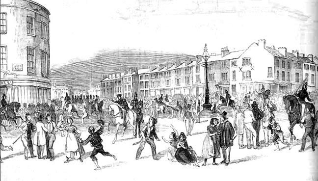
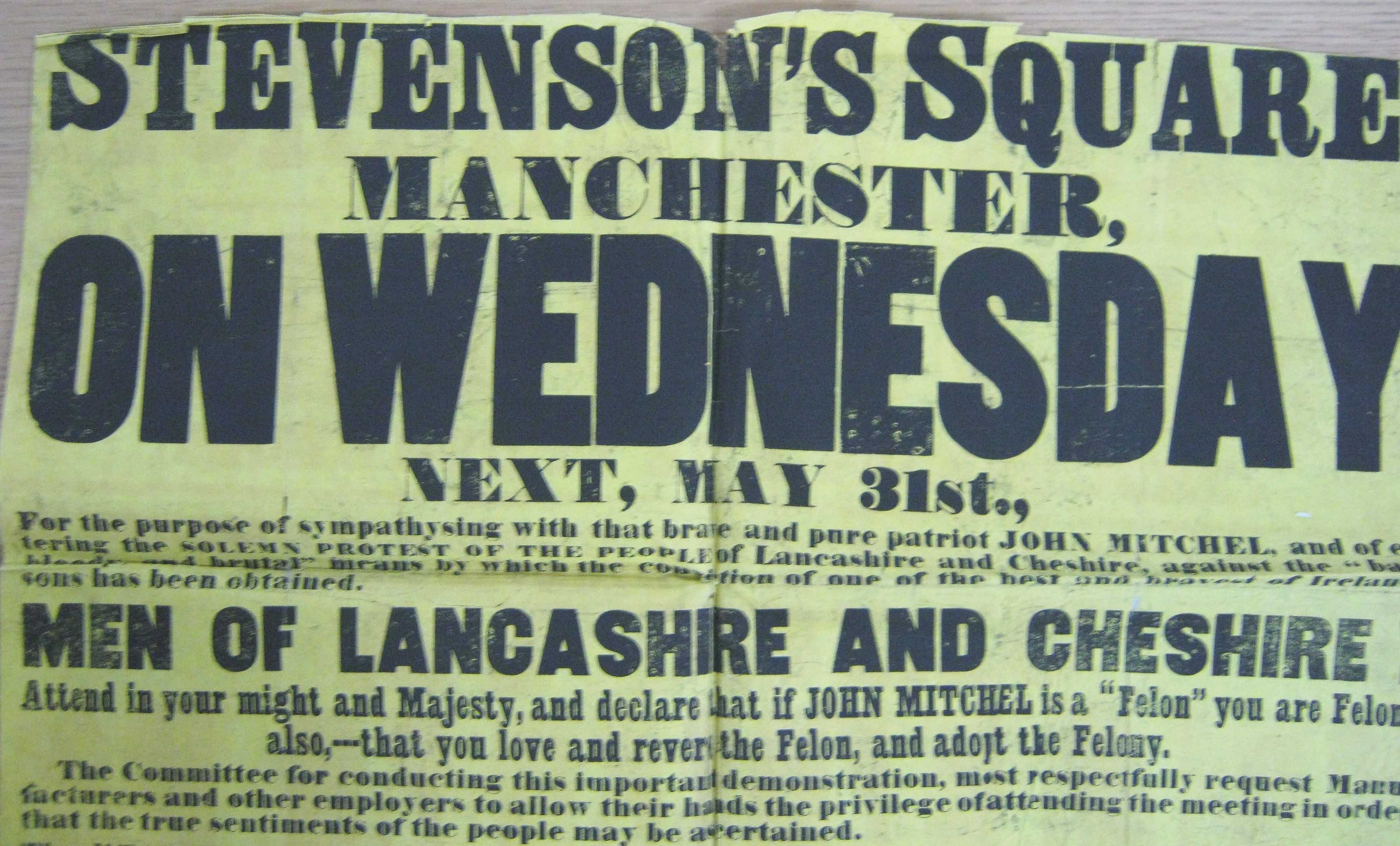
Stevenson's Square was the main square used for Chartist meetings.
Reverend James Scholefield's Christ Church chapel, Every Street, Ancoats, was a central meeting place for radicals from after Peterloo to the Chartists.
", "dlink":"http://maps.google.com/maps?daddr=Every+Street%2C+Manchester%2C+United+Kingdom&t=m&layer=1&doflg=ptk&om=0", "openpopup":"0", "mapwidth":"640", "mapwidthunit":"px", "mapheight":"480", "marker-createdby":"historical1", "marker-createdon":"2017-04-04 19:18:22", "marker-updatedby":"historical1", "marker-updatedon":"2017-04-04 19:18:22", "layerid":["10"], "layername":"Manchester", "layer-createdby":"historical1", "layer-createdon":"2016-02-20 21:14:45", "layer-updatedby":"historical1", "layer-updatedon":"2017-04-04 19:01:15", "controlbox":"1", "overlays_custom":"0", "overlays_custom2":"0", "overlays_custom3":"0", "overlays_custom4":"0", "wms":"0", "wms2":"0", "wms3":"0", "wms4":"0", "wms5":"0", "wms6":"0", "wms7":"0", "wms8":"0", "wms9":"0", "wms10":"0", "kml_timestamp":"", "gpx_url":"", "gpx_panel":"0", "mlm_filter":"0", "mlm_filter_details":"" }}, { "type":"Feature", "geometry": { "type":"Point", "coordinates":[-2.110100,53.549700] }, "properties": { "markerid":"11", "layers":["7"], "requested_layer":["7"], "markername":"Oldham Edge", "basemap":"osm_mapnik", "lat":"53.549700", "lon":"-2.110100", "icon":"", "zoom":"11", "iconUrl":"http://protesthistory.org.uk/wp-content/plugins/leaflet-maps-marker-pro/leaflet-dist/images/marker.png", "address":"Oldham Edge England, United Kingdom", "text":"
Oldham Edge
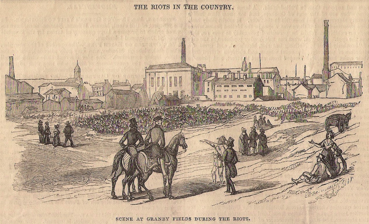
", "dlink":"http://maps.google.com/maps?daddr=Oldham+Edge+England%2C+United+Kingdom&t=m&layer=1&doflg=ptk&om=0", "openpopup":"0", "mapwidth":"75", "mapwidthunit":"%", "mapheight":"480", "marker-createdby":"historical1", "marker-createdon":"2017-04-08 21:39:10", "marker-updatedby":"historical1", "marker-updatedon":"2017-04-08 21:39:10", "layerid":["7"], "layername":"Oldham", "layer-createdby":"historical1", "layer-createdon":"2015-11-16 10:33:38", "layer-updatedby":"historical1", "layer-updatedon":"2015-11-16 10:33:38", "controlbox":"1", "overlays_custom":"1", "overlays_custom2":"1", "overlays_custom3":"1", "overlays_custom4":"1", "wms":"0", "wms2":"0", "wms3":"0", "wms4":"0", "wms5":"0", "wms6":"0", "wms7":"0", "wms8":"0", "wms9":"0", "wms10":"0", "kml_timestamp":"", "gpx_url":"", "gpx_panel":"0", "mlm_filter":"0", "mlm_filter_details":"" }}, { "type":"Feature", "geometry": { "type":"Point", "coordinates":[-2.229090,53.485200] }, "properties": { "markerid":"12", "layers":["10"], "requested_layer":["10"], "markername":"", "basemap":"osm_mapnik", "lat":"53.485200", "lon":"-2.229090", "icon":"", "zoom":"11", "iconUrl":"http://protesthistory.org.uk/wp-content/plugins/leaflet-maps-marker-pro/leaflet-dist/images/marker.png", "address":"George Leigh Street England, United Kingdom", "text":"George Leigh Street was the site of the radical union rooms in the 1810s and 1820s.Granby Row Fields was a site of Chartist meetings and the Plug strikes of 1842
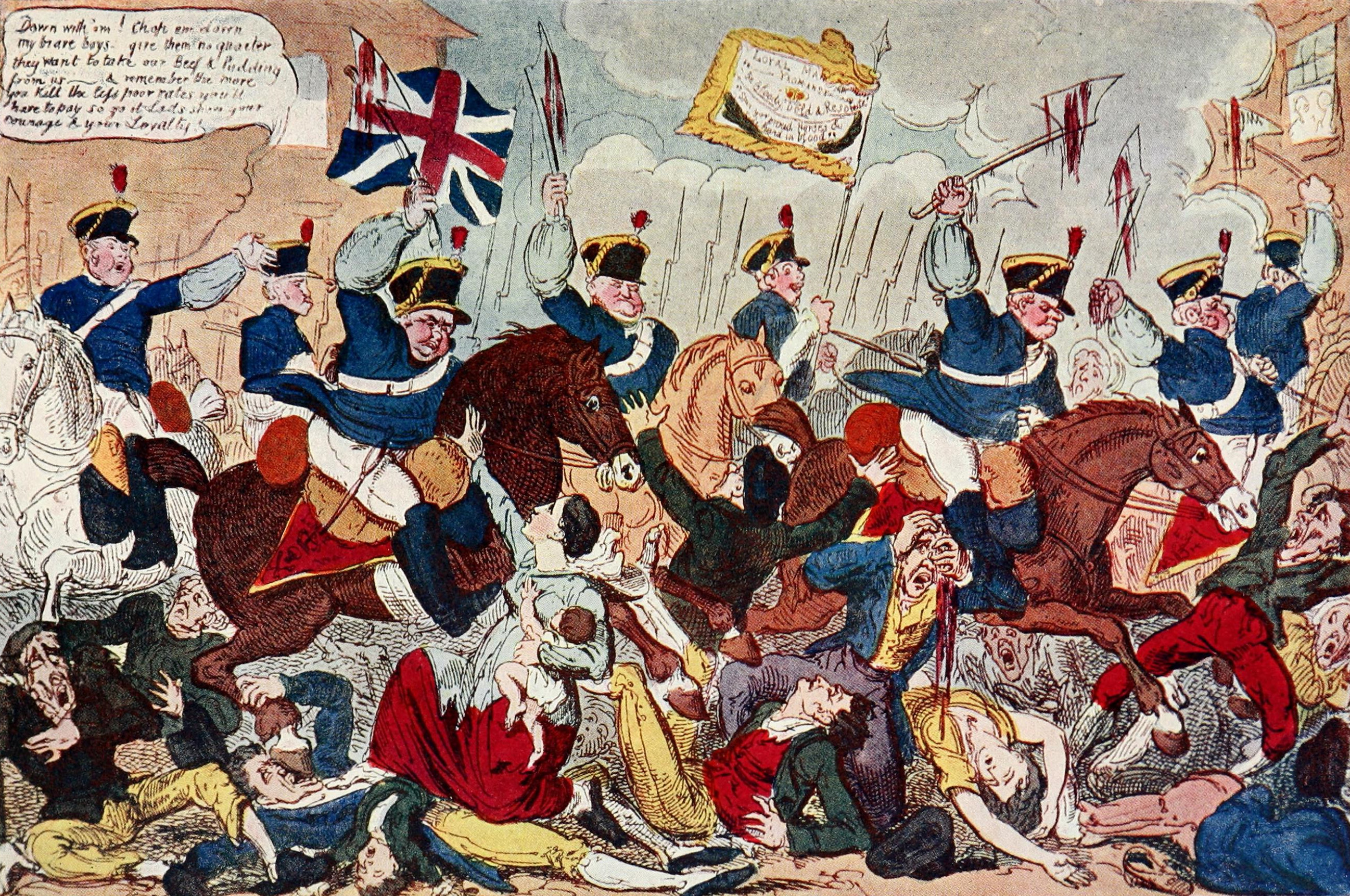
Trial of Feargus O'Connor,
", "dlink":"http://maps.google.com/maps?daddr=Granby+Row+England%2C+United+Kingdom&t=m&layer=1&doflg=ptk&om=0", "openpopup":"0", "mapwidth":"75", "mapwidthunit":"%", "mapheight":"480", "marker-createdby":"historical1", "marker-createdon":"2017-04-13 22:01:19", "marker-updatedby":"historical1", "marker-updatedon":"2017-04-13 22:01:19", "layerid":["10"], "layername":"Manchester", "layer-createdby":"historical1", "layer-createdon":"2016-02-20 21:14:45", "layer-updatedby":"historical1", "layer-updatedon":"2017-04-04 19:01:15", "controlbox":"1", "overlays_custom":"1", "overlays_custom2":"1", "overlays_custom3":"1", "overlays_custom4":"0", "wms":"0", "wms2":"0", "wms3":"0", "wms4":"0", "wms5":"0", "wms6":"0", "wms7":"0", "wms8":"0", "wms9":"0", "wms10":"0", "kml_timestamp":"", "gpx_url":"", "gpx_panel":"0", "mlm_filter":"0", "mlm_filter_details":"" }}, { "type":"Feature", "geometry": { "type":"Point", "coordinates":[-2.252926,53.476759] }, "properties": { "markerid":"14", "layers":["10"], "requested_layer":["10"], "markername":"Hall of Science, Manchester", "basemap":"osm_mapnik", "lat":"53.476759", "lon":"-2.252926", "icon":"", "zoom":"15", "iconUrl":"http://protesthistory.org.uk/wp-content/plugins/leaflet-maps-marker-pro/leaflet-dist/images/marker.png", "address":"", "text":"The Hall of Science was built by the Owenite Socialists in 1839-40 and used by the Chartists for meetings, lectures and socials.
New Mechanics Institute, Poole Street, used for reform meetings and Owenite socialist dinners.
It was set up in opposition to the Mechanics Institute, which was paternalised by the great and good.
https://radicalmanchester.wordpress.com/2011/11/11/the-manchester-mechanics-institute/
", "dlink":"http://maps.google.com/maps?daddr=53.483141,-2.240744&t=m&layer=1&doflg=ptk&om=0", "openpopup":"0", "mapwidth":"75", "mapwidthunit":"%", "mapheight":"480", "marker-createdby":"historical1", "marker-createdon":"2017-04-13 22:01:19", "marker-updatedby":"historical1", "marker-updatedon":"2017-04-13 22:01:19", "layerid":["10"], "layername":"Manchester", "layer-createdby":"historical1", "layer-createdon":"2016-02-20 21:14:45", "layer-updatedby":"historical1", "layer-updatedon":"2017-04-04 19:01:15", "controlbox":"1", "overlays_custom":"1", "overlays_custom2":"0", "overlays_custom3":"0", "overlays_custom4":"0", "wms":"0", "wms2":"0", "wms3":"0", "wms4":"0", "wms5":"0", "wms6":"0", "wms7":"0", "wms8":"0", "wms9":"0", "wms10":"0", "kml_timestamp":"", "gpx_url":"", "gpx_panel":"0", "mlm_filter":"0", "mlm_filter_details":"" }}, { "type":"Feature", "geometry": { "type":"Point", "coordinates":[-2.244262,53.483058] }, "properties": { "markerid":"16", "layers":["10"], "requested_layer":["10"], "markername":"Newall's Buildings, Manchester", "basemap":"osm_mapnik", "lat":"53.483058", "lon":"-2.244262", "icon":"bank_euro.png", "zoom":"11", "iconUrl":"http://protesthistory.org.uk/wp-content/uploads/leaflet-maps-marker-icons/bank_euro.png", "address":"", "text":"Newall's Buildings were opposite the Exchange, and a suite of rooms hired by the Anti-Corn Law Association for their campaign to repeal the Corn Laws in the 1840s.
", "dlink":"http://maps.google.com/maps?daddr=53.483058,-2.244262&t=m&layer=1&doflg=ptk&om=0", "openpopup":"0", "mapwidth":"75", "mapwidthunit":"%", "mapheight":"480", "marker-createdby":"historical1", "marker-createdon":"2017-04-16 15:34:29", "marker-updatedby":"historical1", "marker-updatedon":"2017-04-16 15:34:31", "layerid":["10"], "layername":"Manchester", "layer-createdby":"historical1", "layer-createdon":"2016-02-20 21:14:45", "layer-updatedby":"historical1", "layer-updatedon":"2017-04-04 19:01:15", "controlbox":"1", "overlays_custom":"1", "overlays_custom2":"1", "overlays_custom3":"1", "overlays_custom4":"0", "wms":"0", "wms2":"0", "wms3":"0", "wms4":"0", "wms5":"0", "wms6":"0", "wms7":"0", "wms8":"0", "wms9":"0", "wms10":"0", "kml_timestamp":"", "gpx_url":"", "gpx_panel":"0", "mlm_filter":"0", "mlm_filter_details":"" }}, { "type":"Feature", "geometry": { "type":"Point", "coordinates":[-2.224380,53.478242] }, "properties": { "markerid":"17", "layers":["10"], "requested_layer":["10"], "markername":"People's Institute, Manchester", "basemap":"osm_mapnik", "lat":"53.478242", "lon":"-2.224380", "icon":"", "zoom":"11", "iconUrl":"http://protesthistory.org.uk/wp-content/plugins/leaflet-maps-marker-pro/leaflet-dist/images/marker.png", "address":"", "text":"The People's Institute on Heyrod Street was a Chartist hall used for meetings in 1848.
", "dlink":"http://maps.google.com/maps?daddr=53.478242,-2.224380&t=m&layer=1&doflg=ptk&om=0", "openpopup":"0", "mapwidth":"75", "mapwidthunit":"%", "mapheight":"480", "marker-createdby":"historical1", "marker-createdon":"2017-04-16 15:34:31", "marker-updatedby":"historical1", "marker-updatedon":"2017-04-16 15:34:31", "layerid":["10"], "layername":"Manchester", "layer-createdby":"historical1", "layer-createdon":"2016-02-20 21:14:45", "layer-updatedby":"historical1", "layer-updatedon":"2017-04-04 19:01:15", "controlbox":"1", "overlays_custom":"1", "overlays_custom2":"0", "overlays_custom3":"0", "overlays_custom4":"0", "wms":"0", "wms2":"0", "wms3":"0", "wms4":"0", "wms5":"0", "wms6":"0", "wms7":"0", "wms8":"0", "wms9":"0", "wms10":"0", "kml_timestamp":"", "gpx_url":"", "gpx_panel":"0", "mlm_filter":"0", "mlm_filter_details":"" }}, { "type":"Feature", "geometry": { "type":"Point", "coordinates":[-2.244848,53.477015] }, "properties": { "markerid":"18", "layers":["10"], "requested_layer":["10"], "markername":"Riding School, Manchester", "basemap":"osm_mapnik", "lat":"53.477015", "lon":"-2.244848", "icon":"", "zoom":"11", "iconUrl":"http://protesthistory.org.uk/wp-content/plugins/leaflet-maps-marker-pro/leaflet-dist/images/marker.png", "address":"", "text":"The Riding School on Lower Mosley Street was used for reform and radical meetings 1831-2.
", "dlink":"http://maps.google.com/maps?daddr=53.477015,-2.244848&t=m&layer=1&doflg=ptk&om=0", "openpopup":"0", "mapwidth":"75", "mapwidthunit":"%", "mapheight":"480", "marker-createdby":"historical1", "marker-createdon":"2017-04-17 13:30:32", "marker-updatedby":"historical1", "marker-updatedon":"2017-04-17 13:30:33", "layerid":["10"], "layername":"Manchester", "layer-createdby":"historical1", "layer-createdon":"2016-02-20 21:14:45", "layer-updatedby":"historical1", "layer-updatedon":"2017-04-04 19:01:15", "controlbox":"1", "overlays_custom":"1", "overlays_custom2":"1", "overlays_custom3":"1", "overlays_custom4":"0", "wms":"0", "wms2":"0", "wms3":"0", "wms4":"0", "wms5":"0", "wms6":"0", "wms7":"0", "wms8":"0", "wms9":"0", "wms10":"0", "kml_timestamp":"", "gpx_url":"", "gpx_panel":"0", "mlm_filter":"0", "mlm_filter_details":"" }}]});